Fichier:Syria Ethnoreligious Map.png

Taille de cet aperçu : 711 × 600 pixels. Autres résolutions : 285 × 240 pixels | 569 × 480 pixels | 910 × 768 pixels | 1 214 × 1 024 pixels | 1 778 × 1 500 pixels.
Fichier d’origine (1 778 × 1 500 pixels, taille du fichier : 373 kio, type MIME : image/png)
Ce fichier et sa description proviennent de Wikimedia Commons.
| Description |
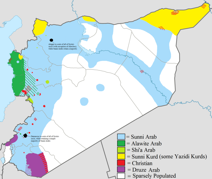
English: Map showing the ethnic and religious distribution of Syria's sects. Very useful map that helps clarify Syria's composition. |
| Date | 8/10/12 |
| Source | File:Syria location map2.svg |
| Auteur | Supreme Deliciousness |
| Autorisation (Réutilisation de ce fichier) |
http://en.wikipedia.org/wiki/File:Syria_location_map2.svg |
Ce fichier est disponible selon les termes de la licence Creative Commons Attribution – Partage dans les Mêmes Conditions 1.0 Générique
- Vous êtes libre :
- de partager – de copier, distribuer et transmettre cette œuvre
- d’adapter – de modifier cette œuvre
- Sous les conditions suivantes :
- paternité – Vous devez donner les informations appropriées concernant l'auteur, fournir un lien vers la licence et indiquer si des modifications ont été faites. Vous pouvez faire cela par tout moyen raisonnable, mais en aucune façon suggérant que l’auteur vous soutient ou approuve l’utilisation que vous en faites.
- partage à l’identique – If you alter, transform, or build upon this work, you must distribute the resulting work under the same license as the original.
Historique du fichier
Cliquer sur une date et heure pour voir le fichier tel qu'il était à ce moment-là.
| Date et heure | Vignette | Dimensions | Utilisateur | Commentaire | |
|---|---|---|---|---|---|
| actuel | 19 août 2012 à 23:31 | | 1 778 × 1 500 (373 kio) | Moester101 | More polishing to respond to Wustenfuchs' concerns. |
| 19 août 2012 à 08:20 |  | 1 778 × 1 500 (372 kio) | Moester101 | updated to reflect new source provided by Wustenfuchs. See talk page of file. | |
| 12 août 2012 à 12:32 |  | 1 778 × 1 500 (372 kio) | Moester101 | Distinguish between Sunni Arab lands and sparsely populated lands, and also added the sources of the map. See talk Page. | |
| 11 août 2012 à 10:32 |  | 1 778 × 1 500 (343 kio) | Moester101 | {{subst:Upload marker added by en.wp UW}} {{Information |Description = {{en|Map showing the ethnic and religious distribution of Syria's sects. Very useful map that helps clarify Syria's composition.}} |Source = File:Syria location map2.svg |Date = 8/1... |
Utilisation du fichier
Les 5 pages suivantes utilisent ce fichier :
Usage global du fichier
Les autres wikis suivants utilisent ce fichier :
- Utilisation sur bg.wikipedia.org
- Utilisation sur de.wikipedia.org
- Utilisation sur en.wikipedia.org
- Utilisation sur hu.wikipedia.org
- Utilisation sur nl.wikipedia.org
- Utilisation sur pt.wikipedia.org